


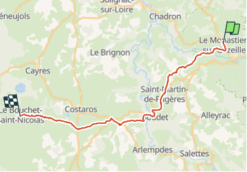
Le Monastier - Le Bouchet

nolsim
User

Length
26 km

Max alt
1219 m

Uphill gradient
828 m
Km-Effort
36 km

Min alt
763 m

Downhill gradient
544 m
Boucle
No
Creation date :
2018-08-18 14:09:14.807
Updated on :
2018-08-18 14:09:14.807
7h39
Difficulty : Medium

FREE GPS app for hiking
 SityTrail
IGN / Geographical institutes
SityTrail Plus
The world is yours!
About
Trail Walking of 26 km to be discovered at Auvergne-Rhône-Alpes, Haute-Loire, Le Monastier-sur-Gazeille. This trail is proposed by nolsim.
Description
Chemin de Stevenson 1
Positioning
Country:
France
Region :
Auvergne-Rhône-Alpes
Department/Province :
Haute-Loire
Municipality :
Le Monastier-sur-Gazeille
Location:
Unknown
Start:(Dec)
Start:(UTM)
578376 ; 4976866 (31T) N.
Comments